
Файл:Gorno badakhshan map.png

Алдын ала көрүүнүн көлөмү: 800 × 598 пиксел Башка уруксаттар: 320 × 239 пиксел | 640 × 479 пиксел | 948 × 709 пиксел.
Түп нуска файл (948 × 709 пиксель, файлдын көлөмү: 20 KB, MIME түрү: image/png)

|
This file requires updating because: The China-Tajikistan border has changed. In doing so, you could add a timestamp to the file.
|
Жыйынтыгы
| Сыпаттама |
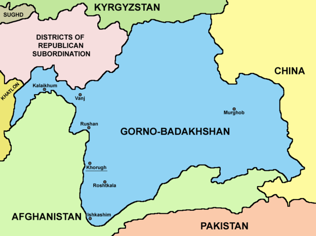
English: Map of Gorno-Badakhshan. |
| Дата | |
| Булак | Өздүк чыгарма |
| Автор | PANONIAN |
Лицензиялоо
I, the copyright holder of this work, hereby publish it under the following license:
| This file is made available under the Creative Commons CC0 1.0 Universal Public Domain Dedication. | |
| The person who associated a work with this deed has dedicated the work to the public domain by waiving all of their rights to the work worldwide under copyright law, including all related and neighboring rights, to the extent allowed by law. You can copy, modify, distribute and perform the work, even for commercial purposes, all without asking permission.
|
Файлдын тарыхы
Файлдын белгилүү бир учурдагы көрүнүшүн көрүү үчүн тийиштүү убакыт/датаны басыңыз
| Убакыт/дата | Миниатюра | Өлчөм | Колдонуучу | Түшүндүрмө | |
|---|---|---|---|---|---|
| учурдагы | 21:15, 9 август 2023 | | 948 × 709 (20 KB) | Lojwe | Cropped 2 % horizontally, 5 % vertically using CropTool with precise mode. |
| 04:08, 27 сентябрь 2021 |  | 970 × 749 (57 KB) | GPinkerton | Reverted to version as of 09:58, 14 May 2013 (UTC) COM:CROP | |
| 17:25, 4 апрель 2021 |  | 970 × 749 (47 KB) | Claude Zygiel | Differenciate international boundaries (black) from administrative of Tadjikistan (grey) | |
| 09:58, 14 май 2013 |  | 970 × 749 (57 KB) | PANONIAN | {{Information |Description ={{en|1=Map of Gorno-Badakhshan.}} |Source ={{own}} |Author =PANONIAN |Date =2013 |Permission = |other_versions = }} |
Шилтемелер
Бул файлды колдонгон барактар жок.
Файлдын глобалдык колдонулушу
Бул файл төмөнкү викилерде колдонулат:
- be.wikipedia.org сайтындагы колдонулушу
- bg.wikipedia.org сайтындагы колдонулушу
- cs.wikipedia.org сайтындагы колдонулушу
- el.wikipedia.org сайтындагы колдонулушу
- en.wikipedia.org сайтындагы колдонулушу
- eo.wikipedia.org сайтындагы колдонулушу
- es.wikipedia.org сайтындагы колдонулушу
- et.wikipedia.org сайтындагы колдонулушу
- fa.wikipedia.org сайтындагы колдонулушу
- fi.wikipedia.org сайтындагы колдонулушу
- fr.wikipedia.org сайтындагы колдонулушу
- gl.wikipedia.org сайтындагы колдонулушу
- hi.wikipedia.org сайтындагы колдонулушу
- id.wikipedia.org сайтындагы колдонулушу
- incubator.wikimedia.org сайтындагы колдонулушу
- it.wikipedia.org сайтындагы колдонулушу
- kaa.wikipedia.org сайтындагы колдонулушу
- ko.wikipedia.org сайтындагы колдонулушу
- lt.wikipedia.org сайтындагы колдонулушу
- pl.wikipedia.org сайтындагы колдонулушу
- pnb.wikipedia.org сайтындагы колдонулушу
- ps.wikipedia.org сайтындагы колдонулушу
- pt.wikipedia.org сайтындагы колдонулушу
- sr.wikipedia.org сайтындагы колдонулушу
- sv.wikipedia.org сайтындагы колдонулушу
- ta.wikipedia.org сайтындагы колдонулушу
- tg.wikipedia.org сайтындагы колдонулушу
- tr.wikipedia.org сайтындагы колдонулушу
- ur.wikipedia.org сайтындагы колдонулушу
- uz.wikipedia.org сайтындагы колдонулушу
- vi.wikipedia.org сайтындагы колдонулушу
- xmf.wikipedia.org сайтындагы колдонулушу
- zh.wikipedia.org сайтындагы колдонулушу