
Файл:San Francisco–Oakland Bay Bridge- New and Old bridges.jpg
Учурда көрсөтүлүүчү өлчөм: 800 × 505 пиксел Башка уруксаттар: 320 × 202 пиксел | 640 × 404 пиксел | 1 024 × 646 пиксел | 1 280 × 807 пиксел | 2 560 × 1 615 пиксел | 4 914 × 3 100 пиксел.
Түп нуска файл (4 914 × 3 100 пиксель, файлдын өлчөмү: 6,94 MB, MIME түрү: image/jpeg)
Жыйынтыгы
| Сыпаттама |
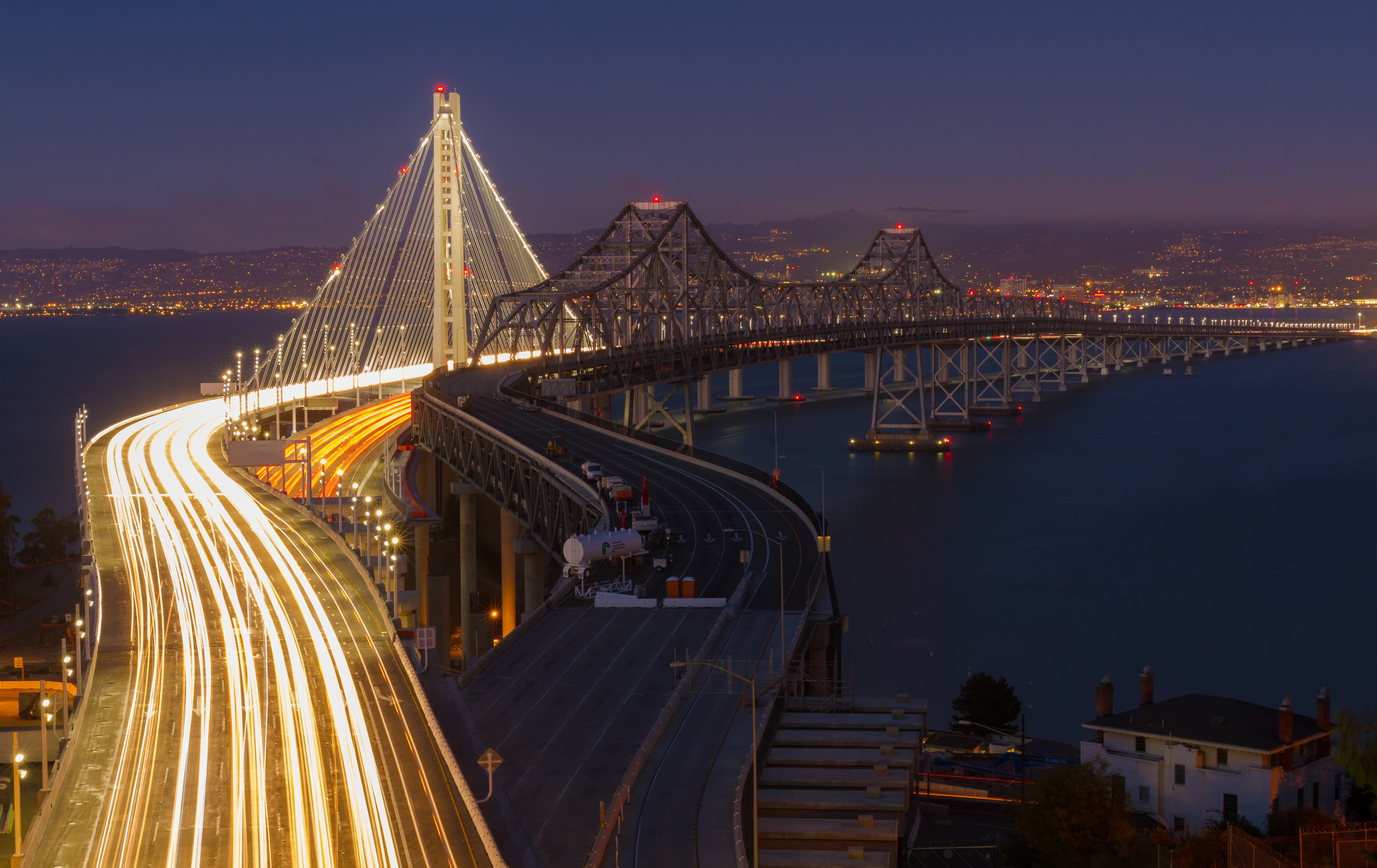
English: Eastern span of the San Francisco–Oakland Bay Bridge. The old and the new bridge, as seen at night from Yerba Buena Island to Oakland (mid September 2013). Deutsch: Östlicher Teil der San Francisco–Oakland Bay Bridge. Die alte und die neue Brücke, Nachtaufnahme von der Yerba Buena Island nach Oakland (Mitte September 2013). Español: Tramo oriental del puente de la Bahía de San Francisco–Oakland. La imagen muestra el puente antiguo y el nuevo, uno al lado del otro, vistos de noche de la isla Yerba Buena en dirección a Oakland a mediados de septiembre de 2013). Français : Travée est du pont de San Francisco-Oakland Bay. L'ancien et le nouveau pont, comme on le voit dans la nuit de Yerba Buena Island pour Oakland (mi-Septembre 2013). Русский: Восточная пролет Сан-Франциско Окленд Бэй Бридж. Старое и Новый мост, как видно ночью с острове Йерба Буэна в Окленд (середина сентября 2013 г.). 中文:东方跨度旧金山 - 奥克兰海湾大桥。旧的和新的桥梁,在夜间看到了从耶巴布埃纳岛奥克兰(中间2013年9月)。
|
|||||||||||||||||||||||
| Дата | Taken on 14 сентябрь 2013, 19:48:32 | |||||||||||||||||||||||
| Булак | Өздүк чыгарма | |||||||||||||||||||||||
| Автор |
|
|||||||||||||||||||||||
| Атрибуция (required by the license) | © Frank Schulenburg / | |||||||||||||||||||||||

| Camera location | | View this and other nearby images on: OpenStreetMap |
|---|
Лицензиялоо
I, the copyright holder of this work, hereby publish it under the following license:
This file is licensed under the Creative Commons Attribution-Share Alike 3.0 Unported license.
- Сиз буларга эркинсиз:
- бөлүшүү – чыгарманы көчүрүү, жайылтуу жана өткөрүп берүү
- ремикс кылуу – чыгарманы ылайыкташтыруу
- Төмөнкү шарттарда:
- атрибуция – Сиз тийиштүү насыя берип, лицензияга шилтеме калтырып жана өзгөртүүлөр болсо көрсөтүшүңүз керек. Сиз муну кандайдыр бир акылга сыярлык жол менен жасай аласыз, бирок лицензиар сизди же сиздин колдонууңузду жактырган кандайдыр бир жол менен эмес.
- Бирдей шарттар боюнча бөлүшүү – If you remix, transform, or build upon the material, you must distribute your contributions under the same or compatible license as the original.

|
Бул сүрөт рамкага салыштырууда жүктөлгөн Уики эстеликти сүйөт — 2013.
|
 |

|
This image was awarded with the 1st prize in the national contest of АКШ in Wiki Loves Monuments 2013 Other languages:
|
|
This image was selected as picture of the day on Wikimedia Commons for 1 April 2014. It was captioned as follows: English: Eastern span of the San Francisco–Oakland Bay Bridge. The old and the new bridge, as seen at night from Yerba Buena Island to Oakland. Other languages:
Bosanski: Istočni krak mosta između San Francisca i Oaklanda. Stari i novi most, pogled noću sa ostrva Yerba Buena prema Oaklandu. Čeština: Východní vyústění mostu San Francisco-Oakland Bay Bridge. Starý a nový most, noční pohled z ostrova Yerba Buena Island mezi San Fraciskem a městem Oakland. English: Eastern span of the San Francisco–Oakland Bay Bridge. The old and the new bridge, as seen at night from Yerba Buena Island to Oakland. Magyar: San Francisco–Oakland Bay Bridge, keleti hídfő. A régi és az új híd esti látképe a Yerba Buena szigetről Oakland felé Nederlands: De oostelijke overspanning van de San Francisco-Oakland Bay Bridge gezien vanaf Yerba Buena Island bij nacht. Links is de nieuwe brug, die in 2013 geopend werd ter vervanging van de brug rechts. Русский: Старый и новый мост между Оклендом и островом Йерба-Буэна — восточная часть моста между Сан-Франциско и Оклендом. 한국어: 2013년 9월 밤에 촬영한 샌프란시스코 - 오클랜드 베이 브리지. 좌측이 새 다리이고, 우측이 옛 다리이다. 中文: 美国旧金山-奥克兰海湾大桥东跨桥,可以看到新旧两座桥。 |
Файлдын тарыхы
Файлдын мурдагы нускасын көрүү үчүн тийиштүү убакыт/датаны басыңыз
| Убакыт/дата | Миниатюра | Өлчөм | Колдонуучу | Түшүндүрмө | |
|---|---|---|---|---|---|
| учурдагы | 08:01, 15 сентябрь 2013 | | 4 914 × 3 100 (6,94 MB) | Frank Schulenburg | Highlights adjusted |
| 04:31, 15 сентябрь 2013 |  | 4 914 × 3 100 (6,89 MB) | Frank Schulenburg | User created page with UploadWizard |
Шилтемелер
Бул файлды колдонгон барактар жок.
Файлдын глобалдык колдонулушу
Бул файл төмөнкү викилерде колдонулат:
- arz.wikipedia.org сайтындагы колдонулушу
- be-tarask.wikipedia.org сайтындагы колдонулушу
- bn.wikipedia.org сайтындагы колдонулушу
- bxr.wikipedia.org сайтындагы колдонулушу
- crh.wikipedia.org сайтындагы колдонулушу
- cs.wikipedia.org сайтындагы колдонулушу
- cv.wikipedia.org сайтындагы колдонулушу
- de.wikipedia.org сайтындагы колдонулушу
- en.wikipedia.org сайтындагы колдонулушу
- Wikipedia:WikiProject U.S. Roads/California
- User talk:Frank Schulenburg
- Eastern span replacement of the San Francisco–Oakland Bay Bridge
- Wikipedia:WikiProject U.S. Roads/Interstate Highways
- Portal:U.S. roads/Selected picture
- Interstate 80 in California
- Wikipedia:Featured pictures/Places/Architecture
- Portal:San Francisco Bay Area/Selected picture/Archive
- Portal:San Francisco Bay Area/Selected article/Archive
- Wikipedia:WikiProject U.S. Roads/Recognized content
- Outstanding Structure Award
- Wikipedia:WikiProject U.S. Roads/California/Recognized content
- Wikipedia:WikiProject U.S. Roads/Main page content
- Wikipedia:WikiProject U.S. Roads/Interstate Highways/Recognized content
- Portal:San Francisco Bay Area/Selected article/2
- Portal:San Francisco Bay Area/Selected picture/53
- User:Mercurywoodrose/SFBA galleries
- Wikipedia:Featured pictures thumbs/49
- User talk:Crisco 1492/Archive 57
- Wikipedia:Featured picture candidates/February-2015
- Wikipedia:Featured picture candidates/San Francisco–Oakland Bay Bridge
- Wikipedia:Wikipedia Signpost/2015-02-25/Featured content
- Wikipedia:Wikipedia Signpost/Single/2015-02-25
- User talk:Crisco 1492/Archive 58
- Portal:U.S. roads/Selected picture/Recommend/2016
- Portal:U.S. roads/Selected picture/June 2016
- Wikipedia:WikiProject U.S. Roads/Newsletter/Issues/Volume09/Issue01
- Wikipedia:Picture of the day/August 2017
- Template:POTD/2017-08-24
- Wikipedia:Main Page history/2017 August 24
- Portal:The arts/Recognized content
- Talk:Eastern span replacement of the San Francisco–Oakland Bay Bridge/Archive 1
- Portal:Architecture/Recognized content
- fa.wikipedia.org сайтындагы колдонулушу
Бул файлдын глобалдык колдонулушун көрүү.