
Файл:Yeniseirivermap.png
Учурда көрсөтүлүүчү өлчөм: 601 × 600 пиксел Башка уруксаттар: 240 × 240 пиксел | 481 × 480 пиксел | 988 × 986 пиксел.
Түп нуска файл (988 × 986 пиксель, файлдын өлчөмү: 325 KB, MIME түрү: image/png)

|
This map image could be re-created using vector graphics as an SVG file. This has several advantages; see Commons:Media for cleanup for more information. If an SVG form of this image is available, please upload it and afterwards replace this template with
{{vector version available|new image name}}.
It is recommended to name the SVG file “Yeniseirivermap.svg”—then the template Vector version available (or Vva) does not need the new image name parameter. |
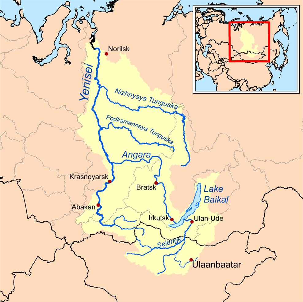
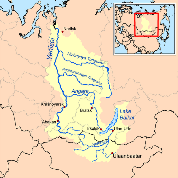
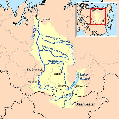
| Сыпаттама | This is a map of the Yenisei River drainage basin, with national borders added. |
| Дата | |
| Булак | Own work using Digital Chart of the World and GTOPO data. |
| Автор | Kmusser |
|
|
This map image could be re-created using vector graphics as an SVG file. This has several advantages; see Commons:Media for cleanup for more information. If an SVG form of this image is available, please upload it and afterwards replace this template with
{{vector version available|new image name}}.
It is recommended to name the SVG file “Yeniseirivermap.svg”—then the template Vector version available (or Vva) does not need the new image name parameter. |
I, the copyright holder of this work, hereby publish it under the following license:
This file is licensed under the Creative Commons Attribution-Share Alike 3.0 Unported license.
- Сиз буларга эркинсиз:
- бөлүшүү – чыгарманы көчүрүү, жайылтуу жана өткөрүп берүү
- ремикс кылуу – чыгарманы ылайыкташтыруу
- Төмөнкү шарттарда:
- атрибуция – Сиз тийиштүү насыя берип, лицензияга шилтеме калтырып жана өзгөртүүлөр болсо көрсөтүшүңүз керек. Сиз муну кандайдыр бир акылга сыярлык жол менен жасай аласыз, бирок лицензиар сизди же сиздин колдонууңузду жактырган кандайдыр бир жол менен эмес.
- Бирдей шарттар боюнча бөлүшүү – If you remix, transform, or build upon the material, you must distribute your contributions under the same or compatible license as the original.
See also
Файлдын тарыхы
Файлдын мурдагы нускасын көрүү үчүн тийиштүү убакыт/датаны басыңыз
| Убакыт/дата | Миниатюра | Өлчөм | Колдонуучу | Түшүндүрмө | |
|---|---|---|---|---|---|
| учурдагы | 13:32, 26 октябрь 2013 | | 988 × 986 (325 KB) | Ras67 | cropped, opt. |
| 18:10, 15 сентябрь 2008 |  | 1 000 × 1 000 (414 KB) | Kmusser | {{Information |Description=This is a map of the Yenisei River drainage basin. |Source=Own work using http://www.maproom.psu.edu/dcw/ Digital Chart of the World and [[http://edc.usgs.gov/products/elevation/gtopo30/gtopo30.html GTO |
Шилтемелер
Бул файл төмөнкү баракта колдонулат:
Файлдын глобалдык колдонулушу
Бул файл төмөнкү викилерде колдонулат:
- af.wikipedia.org сайтындагы колдонулушу
- am.wikipedia.org сайтындагы колдонулушу
- ar.wikipedia.org сайтындагы колдонулушу
- arz.wikipedia.org сайтындагы колдонулушу
- ast.wikipedia.org сайтындагы колдонулушу
- azb.wikipedia.org сайтындагы колдонулушу
- be.wikipedia.org сайтындагы колдонулушу
- bh.wikipedia.org сайтындагы колдонулушу
- bn.wikipedia.org сайтындагы колдонулушу
- bs.wikipedia.org сайтындагы колдонулушу
- ca.wikipedia.org сайтындагы колдонулушу
- cs.wikipedia.org сайтындагы колдонулушу
- cy.wikipedia.org сайтындагы колдонулушу
- da.wikipedia.org сайтындагы колдонулушу
- de.wikipedia.org сайтындагы колдонулушу
- en.wikipedia.org сайтындагы колдонулушу
- Lake Baikal
- Angara
- Yenisey
- Nizhnyaya Tunguska
- New Order (Nazism)
- Soyot
- User:Kmusser/Images
- Tungusic peoples
- Dené–Yeniseian languages
- List of Russian explorers
- Demid Pyanda
- Wikipedia:Graphics Lab/Illustration workshop/Archive/Jan 2011
- Axis powers negotiations on the division of Asia
- Physochlaina
- Yenisei Inscriptions
- eo.wikipedia.org сайтындагы колдонулушу
Бул файлдын глобалдык колдонулушун көрүү.