
Файл:Map of the Samanid amirate at the death of Nasr II, 943.svg

Түп нуска файл (SVG файл, шарттуу түрдө 1 603 × 1 127 пиксел, файлдын өлчөмү: 6,95 MB)
Жыйынтыгы
| Сыпаттама |
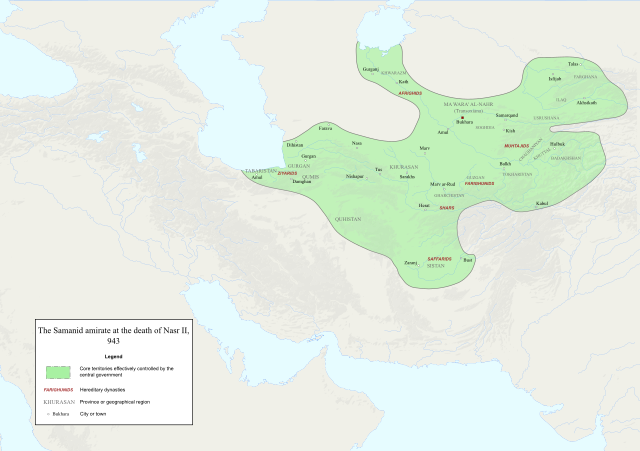
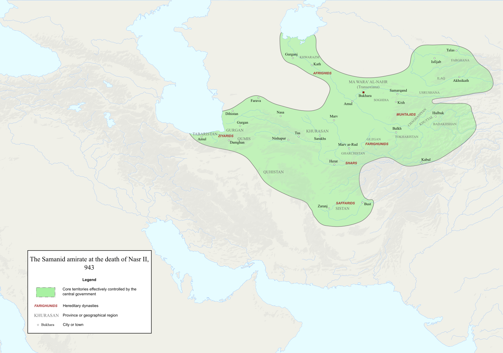
English: Map of the Samanid amirate at the death of Nasr II. |
| Булак |
Map is mainly based on two maps of mid 10th-century Central Asia under the Samanids in the pages 23 and 25 of An Historical Atlas of Central Asia, written by Yuri Bregel and published by Brill, supplied by NAṢR (I) B. AḤMAD (I) B. ESMĀʿIL [1] and Frye, R. N. (1975). "The Sāmānids". In Frye, Richard N. (ed.). The Cambridge History of Iran, Volume 4: From the Arab Invasion to the Saljuqs. Cambridge: Cambridge University Press. pp. 136–161. Since the maps in the source "only" showed Central Asia, I was missing very few parts of the southern border of the Samanids, which I used the following sources to construct;
|
| Автор | Original file by Ro4444, edited by me |
| Уруксат (Бул файл кайрадан колдонууда) |
File:Abbasid_Caliphate_891-892.png |
Лицензиялоо

|
Permission is granted to copy, distribute and/or modify this document under the terms of the GNU Free Documentation License, Version 1.2 or any later version published by the Free Software Foundation; with no Invariant Sections, no Front-Cover Texts, and no Back-Cover Texts. A copy of the license is included in the section entitled GNU Free Documentation License. |
- Сиз буларга эркинсиз:
- бөлүшүү – чыгарманы көчүрүү, жайылтуу жана өткөрүп берүү
- ремикс кылуу – чыгарманы ылайыкташтыруу
- Төмөнкү шарттарда:
- атрибуция – Сиз тийиштүү насыя берип, лицензияга шилтеме калтырып жана өзгөртүүлөр болсо көрсөтүшүңүз керек. Сиз муну кандайдыр бир акылга сыярлык жол менен жасай аласыз, бирок лицензиар сизди же сиздин колдонууңузду жактырган кандайдыр бир жол менен эмес.
- Бирдей шарттар боюнча бөлүшүү – If you remix, transform, or build upon the material, you must distribute your contributions under the same or compatible license as the original.
Файлдын тарыхы
Файлдын белгилүү бир учурдагы көрүнүшүн көрүү үчүн тийиштүү убакыт/датаны басыңыз
| Убакыт/дата | Миниатюра | Өлчөм | Колдонуучу | Түшүндүрмө | |
|---|---|---|---|---|---|
| учурдагы | 14:06, 3 декабрь 2022 | | 1 603 × 1 127 (6,95 MB) | HistoryofIran | ditto |
| 14:02, 3 декабрь 2022 |  | 1 603 × 1 127 (6,95 MB) | HistoryofIran | several adjustments | |
| 02:22, 3 октябрь 2020 |  | 1 603 × 1 127 (6,91 MB) | HistoryofIran | removed banijurids, didnt rule back then | |
| 02:19, 3 октябрь 2020 |  | 1 603 × 1 127 (6,92 MB) | HistoryofIran | banijurids | |
| 16:32, 2 октябрь 2020 |  | 1 603 × 1 127 (6,92 MB) | HistoryofIran | moved Soghdia a bit more west | |
| 16:28, 2 октябрь 2020 |  | 1 603 × 1 127 (6,92 MB) | HistoryofIran | Ghur | |
| 16:22, 2 октябрь 2020 |  | 1 603 × 1 127 (6,92 MB) | HistoryofIran | small fix | |
| 15:02, 2 октябрь 2020 |  | 1 603 × 1 127 (6,94 MB) | HistoryofIran | under Nasr II | |
| 13:16, 2 октябрь 2020 |  | 1 603 × 1 127 (6,93 MB) | HistoryofIran | added capital dot, fixed border in tabaristan | |
| 04:23, 2 октябрь 2020 |  | 1 603 × 1 127 (6,92 MB) | HistoryofIran | {{subst:Upload marker added by en.wp UW}} {{Information |Description = {{en|Map of the traditional domain of the Samanids.}} |Source = Cambridge History of Iran vol 4, Iranica, etc. Might add a more detailed list in the future. |Author = Original file by Ro4444, edited by me |Permission = File:Abbasid_Caliphate_891-892.png }} |
Шилтемелер
Бул файл төмөнкү баракта колдонулат:
Файлдын глобалдык колдонулушу
Бул файл төмөнкү викилерде колдонулат:
- az.wikipedia.org сайтындагы колдонулушу
- en.wikipedia.org сайтындагы колдонулушу
- id.wikipedia.org сайтындагы колдонулушу
- it.wikipedia.org сайтындагы колдонулушу
- lt.wikipedia.org сайтындагы колдонулушу
- mg.wikipedia.org сайтындагы колдонулушу
- pl.wikipedia.org сайтындагы колдонулушу
- ps.wikipedia.org сайтындагы колдонулушу
- ru.wikipedia.org сайтындагы колдонулушу
- ta.wikipedia.org сайтындагы колдонулушу
- tr.wikipedia.org сайтындагы колдонулушу
- uz.wikipedia.org сайтындагы колдонулушу
- zh.wikipedia.org сайтындагы колдонулушу