
Файл:Regierungsbezirke Deutschlands 1981-2008.svg

Size of this PNG preview of this SVG file: 439 × 599 пиксел. Башка уруксаттар: 176 × 240 пиксел | 352 × 480 пиксел | 563 × 768 пиксел | 750 × 1 024 пиксел | 1 500 × 2 048 пиксел | 1 351 × 1 844 пиксел.
Түп нуска файл (SVG файл, шарттуу түрдө 1 351 × 1 844 пиксел, файлдын өлчөмү: 1,5 MB)
Жыйынтыгы
| Сыпаттама |
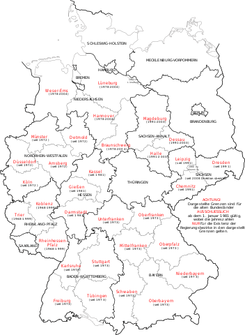
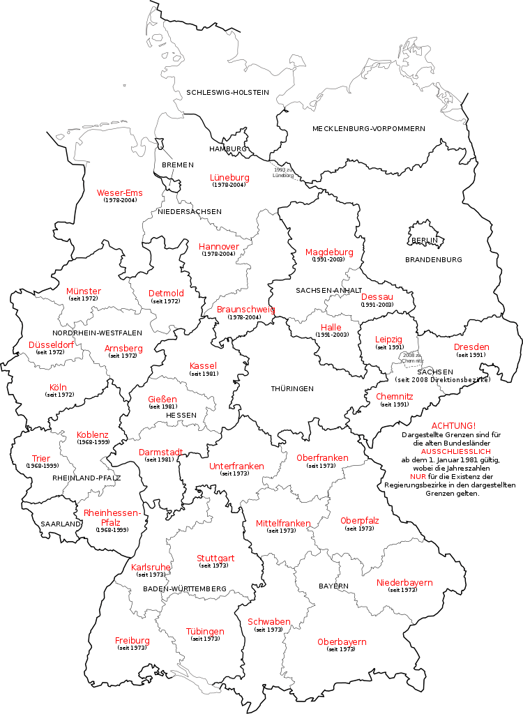
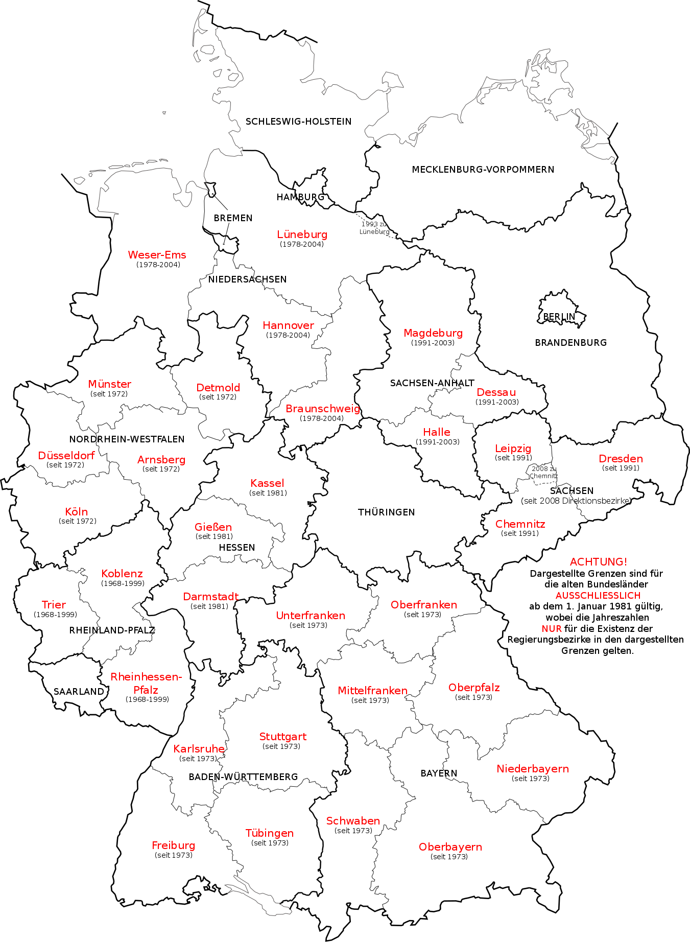
Deutsch: Karte der deutschen Regierungsbezirke und Direktsionsbezirke sowie ehemaliger Regierungsbezirke in Niedersachsen, Sachsen-Anhalt und Rheinland-Pfalz.
English: Map in German language of Germany showing the boundaries of the Regierungsbezirke for FRG from January 1st 1981 and for Germany till 2008. Also displayed are the former RB of Lower Saxony, Rhineland-Palatinate and Saxony-Anhalt.
Русский: Карта административных округов земель Германии и бывших административных округов в землях Нижней Саксонии, Саксонии, Саксонии-Ангальт и Рейнланд-Пфальц. |
| Дата | |
| Булак | Own work, map derived from the image Kfz-Kennzeichen Deutschlands.svg |
| Автор | Bennet Schulte |
| Башка нускалар | Derivative works of this file: Deutsche Rentenversicherung - Regionalträger 2006.svg |
Лицензиялоо
I, the copyright holder of this work, hereby publish it under the following licenses:
This file is licensed under the Creative Commons Attribution-Share Alike 3.0 Unported license.
- Сиз буларга эркинсиз:
- бөлүшүү – чыгарманы көчүрүү, жайылтуу жана өткөрүп берүү
- ремикс кылуу – чыгарманы ылайыкташтыруу
- Төмөнкү шарттарда:
- атрибуция – Сиз тийиштүү насыя берип, лицензияга шилтеме калтырып жана өзгөртүүлөр болсо көрсөтүшүңүз керек. Сиз муну кандайдыр бир акылга сыярлык жол менен жасай аласыз, бирок лицензиар сизди же сиздин колдонууңузду жактырган кандайдыр бир жол менен эмес.
- Бирдей шарттар боюнча бөлүшүү – If you remix, transform, or build upon the material, you must distribute your contributions under the same or compatible license as the original.

|
Permission is granted to copy, distribute and/or modify this document under the terms of the GNU Free Documentation License, Version 1.2 or any later version published by the Free Software Foundation; with no Invariant Sections, no Front-Cover Texts, and no Back-Cover Texts. A copy of the license is included in the section entitled GNU Free Documentation License. |
Сиз тандаган лицензияны тандай аласыз.
Файлдын тарыхы
Файлдын белгилүү бир учурдагы көрүнүшүн көрүү үчүн тийиштүү убакыт/датаны басыңыз
| Убакыт/дата | Миниатюра | Өлчөм | Колдонуучу | Түшүндүрмө | |
|---|---|---|---|---|---|
| учурдагы | 15:23, 1 декабрь 2017 | | 1 351 × 1 844 (1,5 MB) | Reinhard Kraasch | typo corr. |
| 14:30, 1 октябрь 2009 |  | 1 351 × 1 844 (1,39 MB) | Exec | Amt Neuhaus eingebaut | |
| 13:19, 30 сентябрь 2009 |  | 1 351 × 1 844 (1,39 MB) | Exec | Embedded Font again | |
| 13:17, 30 сентябрь 2009 |  | 1 351 × 1 844 (183 KB) | Exec | Reverted to version as of 13:08, 30 September 2009 | |
| 13:16, 30 сентябрь 2009 |  | 1 351 × 1 844 (1,39 MB) | Exec | SVG Font embedding optimzed | |
| 13:08, 30 сентябрь 2009 |  | 1 351 × 1 844 (183 KB) | Exec | Arial Font | |
| 12:49, 30 сентябрь 2009 |  | 1 351 × 1 844 (183 KB) | Exec | {{Information |Description={{en|1=Map in German language of Germany showing the boundaries of the Regierungsbezirke for FRG from January 1st 1981 and for Germany till 2008. There are also shown the former RB of Lower Saxony, Rhineland-Palatinate and Saxon |
Шилтемелер
Бул файл төмөнкү баракта колдонулат:
Файлдын глобалдык колдонулушу
Бул файл төмөнкү викилерде колдонулат:
- ast.wikipedia.org сайтындагы колдонулушу
- az.wikipedia.org сайтындагы колдонулушу
- de.wikipedia.org сайтындагы колдонулушу
- de.wiktionary.org сайтындагы колдонулушу
- el.wikipedia.org сайтындагы колдонулушу
- es.wikipedia.org сайтындагы колдонулушу
- frr.wikipedia.org сайтындагы колдонулушу
- hu.wikipedia.org сайтындагы колдонулушу
- ka.wikipedia.org сайтындагы колдонулушу
- li.wikipedia.org сайтындагы колдонулушу
- pfl.wikipedia.org сайтындагы колдонулушу
- pl.wikipedia.org сайтындагы колдонулушу
- ru.wikipedia.org сайтындагы колдонулушу
- sco.wikipedia.org сайтындагы колдонулушу
- sv.wikipedia.org сайтындагы колдонулушу
- tr.wikipedia.org сайтындагы колдонулушу
- vi.wikipedia.org сайтындагы колдонулушу