
Файл:South America southern tip pol.png

Алдын ала көрүүнүн көлөмү: 800 × 494 пиксел Башка уруксаттар: 320 × 198 пиксел | 640 × 395 пиксел | 1 024 × 632 пиксел | 1 280 × 790 пиксел | 2 560 × 1 581 пиксел | 3 859 × 2 383 пиксел.
Түп нуска файл (3 859 × 2 383 пиксель, файлдын көлөмү: 596 KB, MIME түрү: image/png)
Жыйынтыгы
| Сыпаттама |
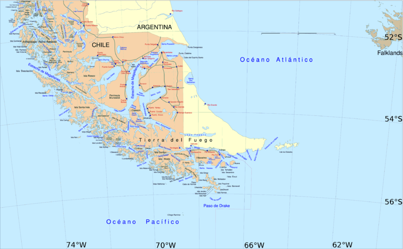
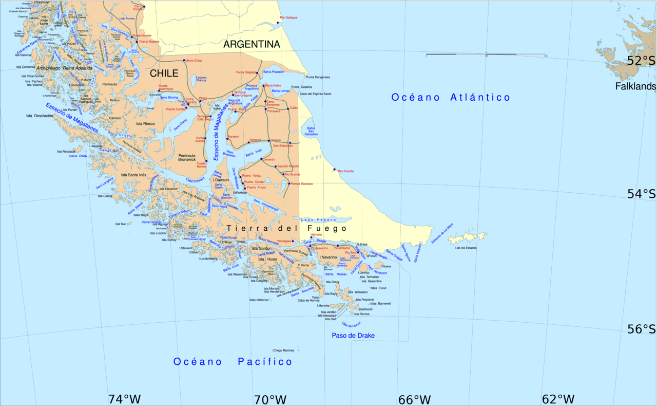
English: Political map of southern Chile and Argentina, from Straits of Magellan to Cape Horn.
Español: Mapa político del sur de Chile y la Argentina, entre el estrecho de Magallanes y el cabo de Hornos. |
||||
| Дата | |||||
| Булак | File:Sur2.gif | ||||
| Автор | User:Createaccount | ||||
| Уруксат (Бул файл кайрадан колдонууда) |
|
||||
| Башка нускалар | Derivative works of this file: Metula.svg |
Лицензиялоо

|
Permission is granted to copy, distribute and/or modify this document under the terms of the GNU Free Documentation License, Version 1.2 or any later version published by the Free Software Foundation; with no Invariant Sections, no Front-Cover Texts, and no Back-Cover Texts. A copy of the license is included in the section entitled GNU Free Documentation License. |
| This file is licensed under the Creative Commons Attribution-Share Alike 3.0 Unported license. | ||
| ||
| This licensing tag was added to this file as part of the GFDL licensing update. |
Файлдын тарыхы
Файлдын белгилүү бир учурдагы көрүнүшүн көрүү үчүн тийиштүү убакыт/датаны басыңыз
| Убакыт/дата | Миниатюра | Өлчөм | Колдонуучу | Түшүндүрмө | |
|---|---|---|---|---|---|
| учурдагы | 14:06, 30 апрель 2016 | | 3 859 × 2 383 (596 KB) | Hohum | Cartographic colours |
| 11:09, 3 апрель 2013 |  | 3 859 × 2 383 (597 KB) | Keysanger | Margin right and top cropped | |
| 10:47, 3 апрель 2013 |  | 3 859 × 2 383 (597 KB) | Keysanger | "Estrecho Nelson" added Bigger Latitude and Longitude within the image empty margin cropped | |
| 19:30, 3 май 2009 |  | 3 894 × 2 441 (639 KB) | Pitichinaccio | different colour | |
| 19:29, 3 май 2009 |  | 3 894 × 2 441 (639 KB) | Pitichinaccio | {{Information |Description={{en|1=political map of southern Chile/Argentina: From Straits of Magellan to Cape Horn}} |Source=File:Sur2.gif |Author=User:Createaccount |Date=2008 |Permission={{GFDL-GMT}}} |other_versions=File:Sur2.gif }} <!-- |
Шилтемелер
Бул файлды колдонгон барактар жок.
Файлдын глобалдык колдонулушу
Бул файл төмөнкү викилерде колдонулат:
- af.wikipedia.org сайтындагы колдонулушу
- als.wikipedia.org сайтындагы колдонулушу
- ar.wikipedia.org сайтындагы колдонулушу
- ast.wikipedia.org сайтындагы колдонулушу
- br.wikipedia.org сайтындагы колдонулушу
- ca.wikipedia.org сайтындагы колдонулушу
- de.wikipedia.org сайтындагы колдонулушу
- de.wiktionary.org сайтындагы колдонулушу
- el.wikipedia.org сайтындагы колдонулушу
- en.wikipedia.org сайтындагы колдонулушу
- Cape Froward
- Porvenir, Chile
- Santa Inés Island
- Puerto Toro
- False Cape Horn
- Puerto del Hambre
- Maritime history of California
- Brunswick Peninsula
- Almirantazgo Fjord
- Fjord of the Mountains
- Primera Angostura
- Aracena Island
- Punta Dúngeness
- Muñoz Gamero Peninsula
- Seno Otway
- Mitre Peninsula
- Marlborough (1876 ship)
Бул файлдын глобалдык колдонулушун көрүү.