
Файл:Thrace and present-day state borderlines.png

Алдын ала көрүүнүн көлөмү: 501 × 600 пиксел Башка уруксаттар: 200 × 240 пиксел | 593 × 710 пиксел.
Түп нуска файл (593 × 710 пиксель, файлдын көлөмү: 142 KB, MIME түрү: image/png)
Жыйынтыгы
| Оп майда |
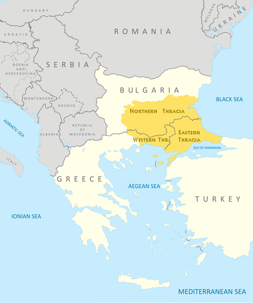
English: Thrace and present-day state borderlines
Български: Тракия и съвременните държавни граници |
|||||||||
| Дата | ||||||||||
| Булак | File:Thrace modern state boundaries.png | |||||||||
| Creator | ||||||||||
| Geotemporal data | ||||||||||
| Bounding box |
|
|||||||||
| Georeferencing | ||||||||||
| Башка нускалар | File:Thrace modern state boundaries.png, File:Thrace and present-day state borderlines zh.png, File:Thrace and present-day state borderlines-ar.png | |||||||||
Лицензиялоо
I, the copyright holder of this work, hereby publish it under the following licenses:
This file is licensed under the Creative Commons Attribution-Share Alike 3.0 Unported license.
- Сиз буларга эркинсиз:
- бөлүшүү – чыгарманы көчүрүү, жайылтуу жана өткөрүп берүү
- ремикс кылуу – чыгарманы ылайыкташтыруу
- Төмөнкү шарттарда:
- атрибуция – Сиз тийиштүү насыя берип, лицензияга шилтеме калтырып жана өзгөртүүлөр болсо көрсөтүшүңүз керек. Сиз муну кандайдыр бир акылга сыярлык жол менен жасай аласыз, бирок лицензиар сизди же сиздин колдонууңузду жактырган кандайдыр бир жол менен эмес.
- Бирдей шарттар боюнча бөлүшүү – If you remix, transform, or build upon the material, you must distribute your contributions under the same or compatible license as the original.

|
Permission is granted to copy, distribute and/or modify this document under the terms of the GNU Free Documentation License, Version 1.2 or any later version published by the Free Software Foundation; with no Invariant Sections, no Front-Cover Texts, and no Back-Cover Texts. A copy of the license is included in the section entitled GNU Free Documentation License. |
Сиз тандаган лицензияны тандай аласыз.

|
This map image could be re-created using vector graphics as an SVG file. This has several advantages; see Commons:Media for cleanup for more information. If an SVG form of this image is available, please upload it and afterwards replace this template with
{{vector version available|new image name}}.
It is recommended to name the SVG file “Thrace and present-day state borderlines.svg”—then the template Vector version available (or Vva) does not need the new image name parameter. |
Файлдын тарыхы
Файлдын белгилүү бир учурдагы көрүнүшүн көрүү үчүн тийиштүү убакыт/датаны басыңыз
| Убакыт/дата | Миниатюра | Өлчөм | Колдонуучу | Түшүндүрмө | |
|---|---|---|---|---|---|
| учурдагы | 09:17, 6 октябрь 2017 | | 593 × 710 (142 KB) | Mélomène | Details |
| 09:57, 24 октябрь 2009 |  | 593 × 710 (145 KB) | Пакко | again | |
| 09:56, 24 октябрь 2009 |  | 600 × 710 (154 KB) | Пакко | some changes | |
| 09:55, 24 октябрь 2009 |  | 3 292 × 3 897 (1,06 MB) | Пакко | SOME CHANGEIS | |
| 19:20, 16 август 2009 |  | 583 × 800 (157 KB) | Пакко | some changes | |
| 13:02, 15 август 2009 |  | 3 074 × 3 750 (954 KB) | Пакко | {{Information |Description={{en|1=Thrace and present-day state borderlines}} {{bg|1=Тракия и съвременните държавни граници}} |Source=File:Thrace modern state boundaries.png |Author=Пакко |Dat |
Шилтемелер
Бул файл төмөнкү баракта колдонулат:
Файлдын глобалдык колдонулушу
Бул файл төмөнкү викилерде колдонулат:
- af.wikipedia.org сайтындагы колдонулушу
- am.wikipedia.org сайтындагы колдонулушу
- ast.wikipedia.org сайтындагы колдонулушу
- azb.wikipedia.org сайтындагы колдонулушу
- ba.wikipedia.org сайтындагы колдонулушу
- bg.wikipedia.org сайтындагы колдонулушу
- bn.wikipedia.org сайтындагы колдонулушу
- br.wikipedia.org сайтындагы колдонулушу
- bs.wikipedia.org сайтындагы колдонулушу
- bs.wiktionary.org сайтындагы колдонулушу
- ca.wikipedia.org сайтындагы колдонулушу
- ckb.wikipedia.org сайтындагы колдонулушу
- crh.wikipedia.org сайтындагы колдонулушу
- cs.wikipedia.org сайтындагы колдонулушу
- cs.wiktionary.org сайтындагы колдонулушу
- da.wikipedia.org сайтындагы колдонулушу
- de.wikipedia.org сайтындагы колдонулушу
- de.wikivoyage.org сайтындагы колдонулушу
- el.wikipedia.org сайтындагы колдонулушу
- en.wikipedia.org сайтындагы колдонулушу
- en.wikiversity.org сайтындагы колдонулушу
- en.wikivoyage.org сайтындагы колдонулушу
- en.wiktionary.org сайтындагы колдонулушу
- eo.wikipedia.org сайтындагы колдонулушу
- es.wikipedia.org сайтындагы колдонулушу
- et.wikipedia.org сайтындагы колдонулушу
- eu.wikipedia.org сайтындагы колдонулушу
- fa.wikipedia.org сайтындагы колдонулушу
- fi.wikipedia.org сайтындагы колдонулушу
- fr.wikipedia.org сайтындагы колдонулушу
- fr.wiktionary.org сайтындагы колдонулушу
- ga.wikipedia.org сайтындагы колдонулушу
- gl.wikipedia.org сайтындагы колдонулушу
- hi.wikipedia.org сайтындагы колдонулушу
- hr.wikipedia.org сайтындагы колдонулушу
- hr.wiktionary.org сайтындагы колдонулушу
- hy.wikipedia.org сайтындагы колдонулушу
- hyw.wikipedia.org сайтындагы колдонулушу
- ia.wikipedia.org сайтындагы колдонулушу
Бул файлдын глобалдык колдонулушун көрүү.