
Файл:Aerial view of an Oyster Reef (22819976251).jpg

Учурда көрсөтүлүүчү өлчөм: 800 × 533 пиксел Башка уруксаттар: 320 × 213 пиксел | 640 × 427 пиксел | 1 024 × 683 пиксел | 1 280 × 853 пиксел | 2 560 × 1 707 пиксел | 4 428 × 2 952 пиксел.
Түп нуска файл (4 428 × 2 952 пиксель, файлдын өлчөмү: 10,98 MB, MIME түрү: image/jpeg)
.jpg)
Жыйынтыгы
| Сыпаттама |
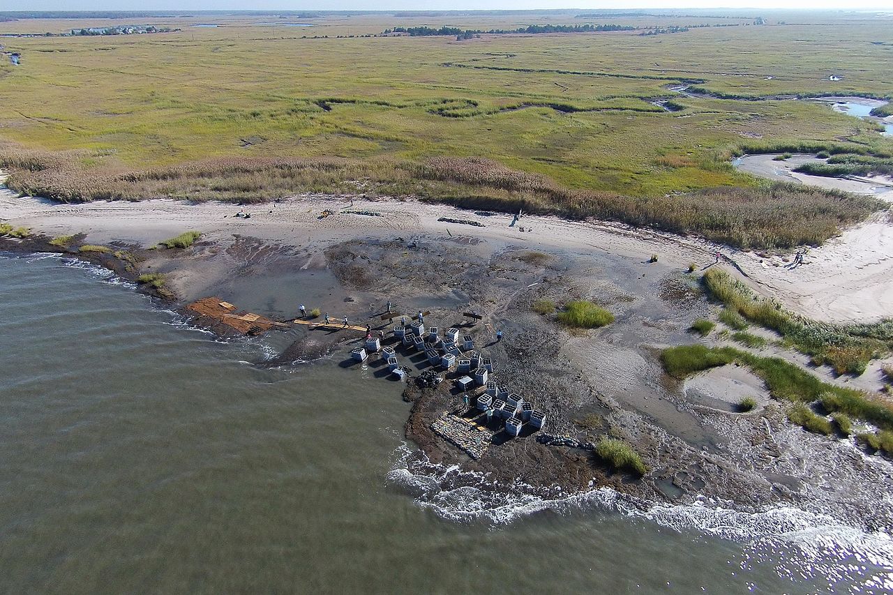
English: The first phase of the Hurricane Sandy-funded living shoreline installation in Downe Township, New Jersey, part of the Gandy’s Beach shoreline protection project, was completed in October 2015. For three days, partners and local volunteers placed a combination of “oyster castles” -- stackable, interlocking blocks of concrete, limestone, crushed shell and silica that encourage oyster larvae to settle -- and bagged oyster shells created by local schools, just offshore. Partner organizations will monitor the integrity of the structure through winter and apply findings to inform future reef installations in the same area next year. The work of this partnership will help stabilize approximately 3,000 feet of beach and tidal marsh shoreline, allowing the coast to heal itself.
|
| Дата | |
| Булак | https://www.flickr.com/photos/usfwsnortheast/22819976251/ |
| Автор | U. S. Fish and Wildlife Service - Northeast Region |
| Уруксат (Бул файл кайрадан колдонууда) |
At the time of upload, the image license was automatically confirmed using the Flickr API. For more information see Flickr API detail. |
| Flickr sets |
|
| Flickr tags |
|
| Camera location | | View this and other nearby images on: OpenStreetMap |
|---|
.jpg¶ms=039.278611_N_-075.243612_E_globe:Earth_type:camera__&language=ky)
Лицензиялоо
This file is licensed under the Creative Commons Attribution 2.0 Generic license.
- Сиз буларга эркинсиз:
- бөлүшүү – чыгарманы көчүрүү, жайылтуу жана өткөрүп берүү
- ремикс кылуу – чыгарманы ылайыкташтыруу
- Төмөнкү шарттарда:
- атрибуция – Сиз тийиштүү насыя берип, лицензияга шилтеме калтырып жана өзгөртүүлөр болсо көрсөтүшүңүз керек. Сиз муну кандайдыр бир акылга сыярлык жол менен жасай аласыз, бирок лицензиар сизди же сиздин колдонууңузду жактырган кандайдыр бир жол менен эмес.
| This image was originally posted to Flickr by U. S. Fish and Wildlife Service - Northeast Region at https://flickr.com/photos/43322816@N08/22819976251. It was reviewed on 28 сентябрь 2016 by FlickreviewR and was confirmed to be licensed under the terms of the cc-by-2.0. |
This image or recording is the work of a U.S. Fish and Wildlife Service employee, taken or made as part of that person's official duties. As a work of the U.S. federal government, the image is in the public domain. For more information, see the Fish and Wildlife Service copyright policy.
|
 |
Файлдын тарыхы
Файлдын мурдагы нускасын көрүү үчүн тийиштүү убакыт/датаны басыңыз
| Убакыт/дата | Миниатюра | Өлчөм | Колдонуучу | Түшүндүрмө | |
|---|---|---|---|---|---|
| учурдагы | 13:22, 28 сентябрь 2016 | | 4 428 × 2 952 (10,98 MB) | Fæ | Flickr Set 72157644908524104, ID 22819976251, Original title Aerial view of an Oyster Reef |
Шилтемелер
Бул файл төмөнкү баракта колдонулат:
Файлдын глобалдык колдонулушу
Бул файл төмөнкү викилерде колдонулат:
- cy.wikipedia.org сайтындагы колдонулушу
- es.wikipedia.org сайтындагы колдонулушу
- ht.wikipedia.org сайтындагы колдонулушу
- uk.wikipedia.org сайтындагы колдонулушу
- www.wikidata.org сайтындагы колдонулушу
.jpg)