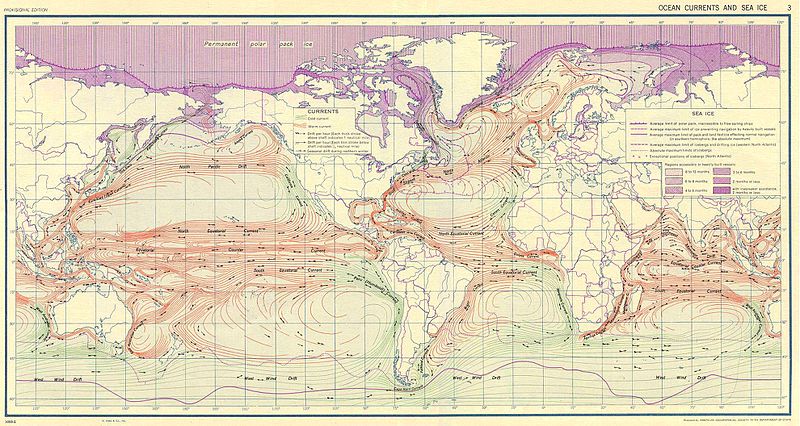
Файл:Ocean currents 1943.jpg

Учурда көрсөтүлүүчү өлчөм: 800 × 426 пиксел Башка уруксаттар: 320 × 170 пиксел | 640 × 341 пиксел | 1 024 × 546 пиксел | 1 280 × 682 пиксел | 2 639 × 1 406 пиксел.
Түп нуска файл (2 639 × 1 406 пиксель, файлдын өлчөмү: 5,14 MB, MIME түрү: image/jpeg)
Файлдын тарыхы
Файлдын мурдагы нускасын көрүү үчүн тийиштүү убакыт/датаны басыңыз
| Убакыт/дата | Миниатюра | Өлчөм | Колдонуучу | Түшүндүрмө | |
|---|---|---|---|---|---|
| учурдагы | 10:58, 6 сентябрь 2016 |  | 2 639 × 1 406 (5,14 MB) | Dencey | new |
| 20:20, 31 март 2005 |  | 2 639 × 1 406 (582 KB) | SEWilco | '''Ocean Currents and Sea Ice from Atlas of World Maps.''' United States Army Service Forces, Army Specialized Training Division. Army Service Forces Manual M-101. 1943 {{PD-PCL}} Source: http://www.lib.utexas.edu/maps/world_maps/ocean_currents_ |
Шилтемелер
Бул файлды колдонгон барактар жок.
Файлдын глобалдык колдонулушу
Бул файл төмөнкү викилерде колдонулат:
- bn.wikipedia.org сайтындагы колдонулушу
- cs.wikipedia.org сайтындагы колдонулушу
- de.wikipedia.org сайтындагы колдонулушу
- en.wikipedia.org сайтындагы колдонулушу
- eo.wikipedia.org сайтындагы колдонулушу
- es.wikipedia.org сайтындагы колдонулушу
- eu.wikipedia.org сайтындагы колдонулушу
- fr.wikipedia.org сайтындагы колдонулушу
- fr.wiktionary.org сайтындагы колдонулушу
- hu.wikipedia.org сайтындагы колдонулушу
- it.wikipedia.org сайтындагы колдонулушу
- ja.wikipedia.org сайтындагы колдонулушу
- lt.wikipedia.org сайтындагы колдонулушу
- nn.wikipedia.org сайтындагы колдонулушу
- oc.wikipedia.org сайтындагы колдонулушу
- pt.wiktionary.org сайтындагы колдонулушу
- sk.wikipedia.org сайтындагы колдонулушу
- sl.wikipedia.org сайтындагы колдонулушу
- sv.wikipedia.org сайтындагы колдонулушу
- tr.wikipedia.org сайтындагы колдонулушу
- vi.wikipedia.org сайтындагы колдонулушу
- zh.wikipedia.org сайтындагы колдонулушу


