
Файл:Syrdaryamap.png
Учурда көрсөтүлүүчү өлчөм: 719 × 600 пиксел Башка уруксаттар: 288 × 240 пиксел | 576 × 480 пиксел | 820 × 684 пиксел.
Түп нуска файл (820 × 684 пиксель, файлдын өлчөмү: 936 KB, MIME түрү: image/png)
Жыйынтыгы

|
This map image could be re-created using vector graphics as an SVG file. This has several advantages; see Commons:Media for cleanup for more information. If an SVG form of this image is available, please upload it and afterwards replace this template with
{{vector version available|new image name}}.
It is recommended to name the SVG file “Syrdaryamap.svg”—then the template Vector version available (or Vva) does not need the new image name parameter. |
| Сыпаттама |
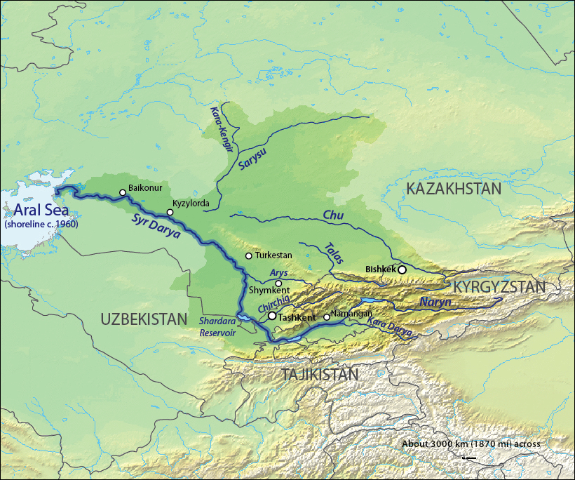
English: Map of the Syr Darya Basin watershed, of the Syr Darya and Chu Rivers — in Central Asia.
Қазақша: Сырдария
Татарча / tatarça: Сырдәрья |
| Дата | to 06 |
| Булак | Background and river course data from http://www2.demis.nl/mapserver/mapper.asp |
| Автор | Background layer attributed to DEMIS Mapserver, map created by Shannon1 |
| Уруксат (Бул файл кайрадан колдонууда) |
Map created from DEMIS Mapserver, which are public domain. |
| Башка нускалар |
Derivative works of this file: |
Лицензиялоо
I, the copyright holder of this work, hereby publish it under the following licenses:

|
Permission is granted to copy, distribute and/or modify this document under the terms of the GNU Free Documentation License, Version 1.2 or any later version published by the Free Software Foundation; with no Invariant Sections, no Front-Cover Texts, and no Back-Cover Texts. A copy of the license is included in the section entitled GNU Free Documentation License. |
This file is licensed under the Creative Commons Attribution-Share Alike 4.0 International, 3.0 Unported, 2.5 Generic, 2.0 Generic and 1.0 Generic license.
- Сиз буларга эркинсиз:
- бөлүшүү – чыгарманы көчүрүү, жайылтуу жана өткөрүп берүү
- ремикс кылуу – чыгарманы ылайыкташтыруу
- Төмөнкү шарттарда:
- атрибуция – Сиз тийиштүү насыя берип, лицензияга шилтеме калтырып жана өзгөртүүлөр болсо көрсөтүшүңүз керек. Сиз муну кандайдыр бир акылга сыярлык жол менен жасай аласыз, бирок лицензиар сизди же сиздин колдонууңузду жактырган кандайдыр бир жол менен эмес.
- Бирдей шарттар боюнча бөлүшүү – If you remix, transform, or build upon the material, you must distribute your contributions under the same or compatible license as the original.
Сиз тандаган лицензияны тандай аласыз.
Файлдын тарыхы
Файлдын мурдагы нускасын көрүү үчүн тийиштүү убакыт/датаны басыңыз
| Убакыт/дата | Миниатюра | Өлчөм | Колдонуучу | Түшүндүрмө | |
|---|---|---|---|---|---|
| учурдагы | 03:11, 18 октябрь 2013 | | 820 × 684 (936 KB) | Shannon1 | redrew and fixed watershed boundary |
| 09:21, 8 январь 2011 |  | 1 101 × 866 (1,65 MB) | Sibom | chu | |
| 09:20, 8 январь 2011 |  | 1 101 × 866 (1,65 MB) | Sibom | чу | |
| 03:04, 7 февраль 2010 |  | 1 101 × 866 (1,51 MB) | Shannon1 | {{Information |Description={{en|1=Map of the watershed of the Syr Darya in Central Asia, that drains to the Aral Sea.}} |Source=Background and river course data from http://www2.demis.nl/mapserver/mapper.asp |Author=Background layer attributed to DEMIS M |
Шилтемелер
Файлдын глобалдык колдонулушу
Бул файл төмөнкү викилерде колдонулат:
- af.wikipedia.org сайтындагы колдонулушу
- ar.wikipedia.org сайтындагы колдонулушу
- ast.wikipedia.org сайтындагы колдонулушу
- bg.wikipedia.org сайтындагы колдонулушу
- bh.wikipedia.org сайтындагы колдонулушу
- bn.wikipedia.org сайтындагы колдонулушу
- cs.wikipedia.org сайтындагы колдонулушу
- cv.wikipedia.org сайтындагы колдонулушу
- da.wikipedia.org сайтындагы колдонулушу
- de.wikipedia.org сайтындагы колдонулушу
- en.wikipedia.org сайтындагы колдонулушу
- es.wikipedia.org сайтындагы колдонулушу
- et.wikipedia.org сайтындагы колдонулушу
- fi.wikipedia.org сайтындагы колдонулушу
- fr.wikipedia.org сайтындагы колдонулушу
- he.wikipedia.org сайтындагы колдонулушу
- hi.wikipedia.org сайтындагы колдонулушу
- hr.wikipedia.org сайтындагы колдонулушу
- hu.wikipedia.org сайтындагы колдонулушу
- hy.wikipedia.org сайтындагы колдонулушу
- id.wikipedia.org сайтындагы колдонулушу
Бул файлдын глобалдык колдонулушун көрүү.