
Файл:GoldenHorde1300.png

Учурда көрсөтүлүүчү өлчөм: 800 × 481 пиксел Башка уруксаттар: 320 × 193 пиксел | 640 × 385 пиксел | 1 024 × 616 пиксел | 1 436 × 864 пиксел.
Түп нуска файл (1 436 × 864 пиксель, файлдын өлчөмү: 47 KB, MIME түрү: image/png)

|
This map image could be re-created using vector graphics as an SVG file. This has several advantages; see Commons:Media for cleanup for more information. If an SVG form of this image is available, please upload it and afterwards replace this template with
{{vector version available|new image name}}.
It is recommended to name the SVG file “GoldenHorde1300.svg”—then the template Vector version available (or Vva) does not need the new image name parameter. |
Жыйынтыгы
| Сыпаттама |
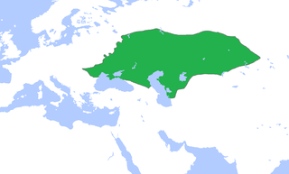
English: Locator map of the Golden Horde, c. 1300.
(Partially based on Atlas of World History (2007) - The World 1200-1300, map) |
| Дата | |
| Булак | Өздүк чыгарма |
| Автор | Gabagool |
Лицензиялоо
I, the copyright holder of this work, hereby publish it under the following license:
This file is licensed under the Creative Commons Attribution 3.0 Unported license.
- Сиз буларга эркинсиз:
- бөлүшүү – чыгарманы көчүрүү, жайылтуу жана өткөрүп берүү
- ремикс кылуу – чыгарманы ылайыкташтыруу
- Төмөнкү шарттарда:
- атрибуция – Сиз тийиштүү насыя берип, лицензияга шилтеме калтырып жана өзгөртүүлөр болсо көрсөтүшүңүз керек. Сиз муну кандайдыр бир акылга сыярлык жол менен жасай аласыз, бирок лицензиар сизди же сиздин колдонууңузду жактырган кандайдыр бир жол менен эмес.
Файлдын тарыхы
Файлдын мурдагы нускасын көрүү үчүн тийиштүү убакыт/датаны басыңыз
| Убакыт/дата | Миниатюра | Өлчөм | Колдонуучу | Түшүндүрмө | |
|---|---|---|---|---|---|
| учурдагы | 15:58, 16 ноябрь 2022 | | 1 436 × 864 (47 KB) | Gyalu22 | Reverted to version as of 16:08, 5 June 2009 (UTC) |
| 16:12, 7 июнь 2021 |  | 1 436 × 864 (28 KB) | Devlet Geray | Reverted to version as of 11:20, 4 June 2018 (UTC) they paid tribute to the Khan and because of this could trade but there were no independent states in Southern Crimea | |
| 12:04, 4 июнь 2018 |  | 1 436 × 864 (28 KB) | Julieta39 | No Golden Horde control on the Southern Crimea (byzantine, later Theodoro principality) | |
| 11:20, 4 июнь 2018 |  | 1 436 × 864 (28 KB) | Julieta39 | Shorelines, no modern dam lakes, Hungary and Galicia no ruled by Golden Horde | |
| 16:08, 5 июнь 2009 |  | 1 436 × 864 (47 KB) | Gabagool | slightly cropped | |
| 13:00, 25 апрель 2009 |  | 1 644 × 959 (56 KB) | Gabagool | {{Information |Description={{en|1=Locator map of the Golden Horde, c. 1300. (Partially based on ''Atlas of World History'' (2007) - The World 1200-1300, map)}} |Source=Own work by uploader |Author=Gabagool / Jarle Grøhn |Date=2009-04-2 |
Шилтемелер
Бул файл төмөнкү баракта колдонулат:
Файлдын глобалдык колдонулушу
Бул файл төмөнкү викилерде колдонулат:
- af.wikipedia.org сайтындагы колдонулушу
- ar.wikipedia.org сайтындагы колдонулушу
- arz.wikipedia.org сайтындагы колдонулушу
- ast.wikipedia.org сайтындагы колдонулушу
- azb.wikipedia.org сайтындагы колдонулушу
- az.wikipedia.org сайтындагы колдонулушу
- be.wikipedia.org сайтындагы колдонулушу
- bs.wikipedia.org сайтындагы колдонулушу
- ca.wikipedia.org сайтындагы колдонулушу
- cs.wikipedia.org сайтындагы колдонулушу
- cv.wikipedia.org сайтындагы колдонулушу
- cy.wikipedia.org сайтындагы колдонулушу
- da.wikipedia.org сайтындагы колдонулушу
- el.wikipedia.org сайтындагы колдонулушу
- en.wikipedia.org сайтындагы колдонулушу
- eo.wikipedia.org сайтындагы колдонулушу
- es.wikipedia.org сайтындагы колдонулушу
- et.wikipedia.org сайтындагы колдонулушу
- eu.wikipedia.org сайтындагы колдонулушу
- fa.wikipedia.org сайтындагы колдонулушу
- fr.wikipedia.org сайтындагы колдонулушу
- ga.wikipedia.org сайтындагы колдонулушу
- gl.wikipedia.org сайтындагы колдонулушу
- hi.wikipedia.org сайтындагы колдонулушу
- hr.wikipedia.org сайтындагы колдонулушу
- hu.wikipedia.org сайтындагы колдонулушу
- hy.wikipedia.org сайтындагы колдонулушу
- id.wikipedia.org сайтындагы колдонулушу
- incubator.wikimedia.org сайтындагы колдонулушу
Бул файлдын глобалдык колдонулушун көрүү.